Snowatch 2019 Season Outlook


By Pete ‘The Frog’ Taylor
Snow Forecastor & Owner
snowatch.com.au
A look at the coming snow season for Australia
(posted: 06/05/19 – 10pm)
As per usual at this time of year everyone wants to know what the coming season has in store, and I’m no different. We would all love to see a couple of early dumps before the opening weekend and then consistent top ups each week through to September, but that’s not realistic. So what is?
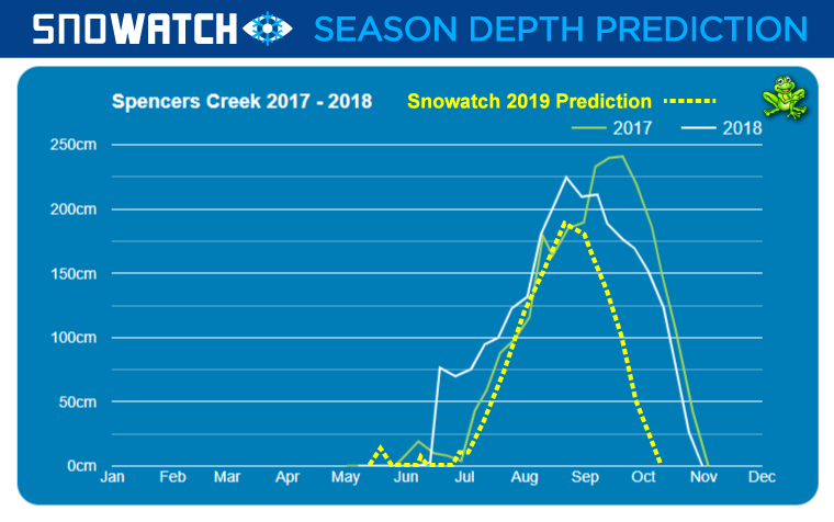
An average June is considered a bit of a write off, and only for the desperate who don’t mind skiing on mostly man made snow. Most resorts know this and have early season festivals and events planned to fill the void. The resorts have pumped millions of dollars into snowmaking infrastructure over the last 20+ years and it has meant that June can actually have decent skiing and boarding even without natural snow, we just need cold clear nights. I remember below average snowfalls seasons at Thredbo that have seen top to bottom skiing on the Crackenback/Kosi Supertrail from June through to closing weekend in October because of extended periods of cold clear nights from large blocking high pressure systems. 2017 was one of the worst starts to a season on record. Warm early temps and some rain meant there was little to no snowmaking and virtually no natural snow for the whole of June. July saw three dumps and another in early August and the season was in full swing. The snow kept on falling and peaked in late September (much later that the usual mid August peak). Last year the first decent snow was a bit earlier in mid June and peaked early August.
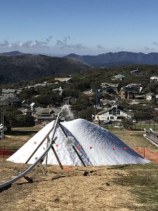
Now to season 2019. The coming snow season will start to get a lot of traction in the media later this week with some decent snow likely to fall in the mountains, but with it still being a month before the season starts it’s unlikely the snow is going to hang around for long. It may help Mt Buller add a bit to their already quite large stockpile of snow thanks to their snow factory technology that makes snow at temps well above zero. This pretty much guarantees them to have at least Bourke Street running for the opening weekend.

Most resorts start to make snow in the third week of May, weather permitting and Perisher a little before that. It wouldn’t surprise me if Perisher was to make an early move and turn on the guns with cold nights forecast for next week after the snowfalls clear, but we will just have to wait and see for that one.
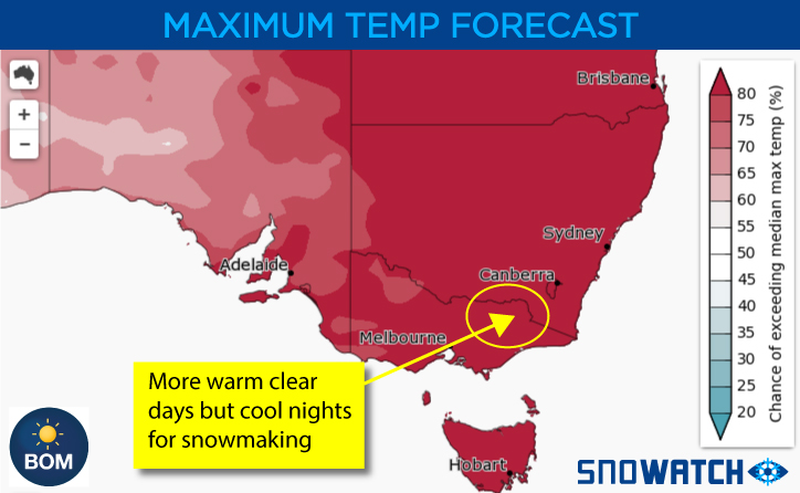
Current weather patterns suggest a drier than average start to the season and also daytime maximum temperatures to be higher than average. This is both good and bad. It means we are not likely get a lot of natural snow but we are likely to see large blocking high pressure systems dominating over the SE of the country. This is fairly normal for this time and year and it should also mean that we should get extended periods of cold night for the snow guns to fire up. With not a lot of rain on the cards early on then it’s quite likely we should see skiing and boarding on the slopes with snowmaking.

The BOM says there is a 70% chance of an El Nino forming towards the end of the season with warm ocean surface temps in the North Pacific, although cool temps at lower depths suggest if El Nino does happen it will be short lived. This shouldn’t really have too much to do with the snow season if it does happen as it will be quite late and probably only weak anyway.
The next month
Early snow this week will increase interest in the coming season but probably won’t have any real bearing on it. Some light snow is possible around the 22nd but it could also be just light showers with some snow up top. At the moment most low pressure systems will slip south just under the mountains. The last week of May is showing some promise for snow, but at this stage I’d say only around 5cm or so, which would be a nice help for the snowmakers to work with.
Early June should see snow around the 3rd-5th with around 5-10cm (fingers crossed for a bit more than that). Following this I see a period of not much snow and unfortunately warmer temps with the occasional shower. So the start of the season from what I can see is that we will be pretty much relying on the snowmakers to fire up to to get runs open.
The high pressure systems look to dominate during mid June and unless we can get a freak dump from somewhere we may be looking at another late start. I see July being another decent one as will August. The highs should weaken early July and let the cold fronts move a bit further north into the mountains and resorts, hopefully early enough for the school holidays, but it may be touch and go.

I do see a lot of similarities with 2017 and 2018 (apart from the mid June first dump last year), although I wouldn’t expect to hit such great heights or also for the snow to keep falling well into late September but I do see it being a bit above average as far as peak depth goes. I’d be looking at around 180-190cm at Spencer’s Creek.
With all that being said, just remember the weather is a fickle thing and we could easily see a cold front slip north and hit the mountains early, it only takes one dump to get things going, it’s just that it’s not very likely looking at the current patterns, charts and previous seasons data.
Keep an eye on the Snowatch long range forecast for daily updates on what coming over the next month and also the daily 15 day forecasts for the resorts.
Here’s to a good season!
The Frog


I’ve been following The Frog’s snow forecasts since I was 16 which makes it now about 20 years… Back in the day of the snowinfo.com.au forums… Thanks Frog, you always seem to get it right!
fingers crossed Pete