Village Elevation: 1550m / Summit Elevation: 1614m / Total number of lifts: 10 + tube lift / Highest Lifted Point: 1614m / Lowest Lifted Point: 1492m
 Forecasts by
Pete ‘The Frog’ Taylor

LIVE TEMP:
PREDICTED SNOWFALL
NEXT 5 DAYS: 4-7cm
NEXT 10 DAYS: 6-12cm
NEXT 15 DAYS: 7-15cm
LIVE CAMS

NEXT 4 DAYS
10 DAY OUTLOOK
Updated: July 3rd, 6:36am (Forecast Period 6am-6am<)
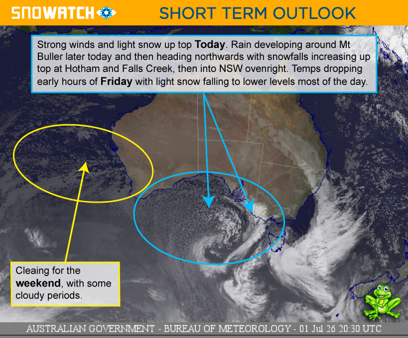
FRIDAY 3RD

Morning
➤
Midday
➤

Night
SNOW: 4 - 7cm
Light snowfalls during the morning and afternoon above around 1100m. Winds very strong and easing overnight. Snow guns on overnight.
CURR TEMP
SNOWMAKING
POSSIBLE
WIND
NW-WSW
STRONG

SATURDAY 4TH
Morning
➤
Midday
➤

Night
SNOW: 0cm
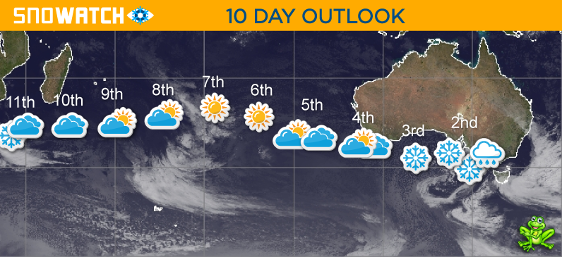
A cool and partly cloudy day in the north and mostly cloudy in the south.
SNOWMAKING
POSSIBLE
WIND
SW-SSW
MODERATE
SUNDAY 5TH
Morning
➤
Midday
➤
Night
SNOW: 0cm
Mostly cloudy in the north and partly cloudy in the south.
SNOWMAKING
POSSIBLE
WIND
SSE
LIGHT
➤
MODERATE

MONDAY 6TH
Morning
➤

Midday
➤
Night
SNOW: 0cm
Some early cloud in the north, clearing to a mostly fine day.
SNOWMAKING
POSSIBLE
WIND
SE-NW
LIGHT
TUESDAY 7TH
Morning
➤
Midday
➤
Night
SNOW: 0cm
A fine and sunny day. Cloud increasing overnight.
SNOWMAKING
POSSIBLE
WIND
SE-NNE
LIGHT
WEDNESDAY 8TH
Morning
➤
Midday
➤
Night
SNOW: 0cm
A partly cloudy day.
SNOWMAKING
POSSIBLE
WIND
S
LIGHT
THURSDAY 9TH
Morning
➤
Midday
➤
Night
SNOW: 0cm
A mostly fine day with some cloudy periods.
SNOWMAKING
POSSIBLE
WIND
SSE
LIGHT
FRIDAY 10TH
Morning
➤
Midday
➤
Night
SNOW: 0cm
A partly cloudy day. Cloud increasing in the north overnight.
SNOWMAKING
POSSIBLE
WIND
NNE
LIGHT
SATURDAY 11TH
Morning
➤
Midday
➤
Night
SNOW: 0cm
A mostly cloudy day with the chance of some light snow flurries at times in the north.
SNOWMAKING
POSSIBLE
WIND
NNW-NW
MODERATE
SUNDAY 12TH
Morning
➤
Midday
➤
Night
SNOW: 2 - 5cm
Cool and cloudy with possible snow showers developing later in the north above 1300m.
SNOWMAKING
LIKELY
WIND
NW-S
MODERATE
MONDAY 13TH
Morning
➤
Midday
➤
Night
SNOW: 1 - 3cm
Cool with light snow showers - mainly in the north above 1300m.
SNOWMAKING
POSSIBLE
WIND
S
MODERATE
TUESDAY 14TH
Morning
➤
Midday
➤
Night
SNOW: 0cm
Cool with light snow showers above around 1300m.
SNOWMAKING
POSSIBLE
WIND
W-WSW
MODERATE
WEDNESDAY 15TH

Morning
➤
Midday
➤
Night
SNOW: 0cm
Cool with light scattered snow showers above around 1300m.
SNOWMAKING
POSSIBLE
WIND
WSW-SW
MODERATE
THURSDAY 16TH
Morning
➤
Midday
➤
Night
SNOW: 0cm
Cool and cloudy with possible snow flurries at times.
SNOWMAKING
POSSIBLE
WIND
SW
MODERATE
FRIDAY 17TH
Morning
➤
Midday
➤
Night
SNOW: 0cm
SNOWMAKING
UNLIKELY
WIND
LIGHT