Village Elevation: 1600m / Summit Elevation: 1842m / Total number of lifts: 14 / Highest Lifted Point: 1780m / Lowest Lifted Point: 1525m International Poma
 Forecasts by
Pete ‘The Frog’ Taylor

LIVE TEMP: -1.5
PREDICTED SNOWFALL
NEXT 5 DAYS: 0cm
NEXT 10 DAYS: 3-10cm
NEXT 15 DAYS: 6-19cm
LIVE CAMS

NEXT 4 DAYS
10 DAY OUTLOOK
Updated: June 26th, 6:27am (Forecast Period 6am-6am<)
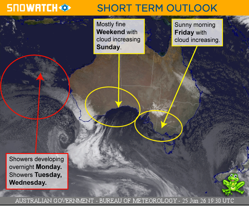
FRIDAY 26TH

Morning
➤

Midday
➤
Night
SNOW: 0cm
Mostly sunny with some cloudy periods in the afternoon.
SNOWMAKING
POSSIBLE
WIND
W-SE
LIGHT

SATURDAY 27TH
Morning
➤
Midday
➤
Night
SNOW: 0cm
A fine and sunny day.
CURR TEMP
-1.5
SNOWMAKING
POSSIBLE
WIND
ENE-SE
LIGHT
SUNDAY 28TH
Morning
➤
Midday
➤

Night
SNOW: 0cm
Mostly fine with some cloudy periods in the north in the afternoon. Cloud increasing overnight.
SNOWMAKING
UNLIKELY
WIND
NNE-N
MODERATE

MONDAY 29TH
Morning
➤
Midday
➤
Night
SNOW: 0cm
A cloudy day with showers developing in the south overnight. Winds increasing.
SNOWMAKING
UNLIKELY
WIND
N
MODERATE
➤
STRONG
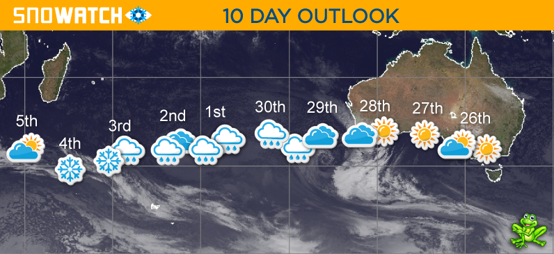
TUESDAY 30TH

Morning
➤
Midday
➤
Night
SNOW: 0cm
Showers developing. Winds gusty about the peaks.
SNOWMAKING
UNLIKELY
WIND
NNW
STRONG
➤
MODERATE
WEDNESDAY 1ST
Morning
➤
Midday
➤

Night
SNOW: 0cm
Light scattered showers during the day that will increase to heavy rain overnight. Winds reaching destructive force - possibly reaching over 110km/h at times.
SNOWMAKING
UNLIKELY
WIND
N-NNW
STRONG
THURSDAY 2ND
Morning
➤
Midday
➤
Night
SNOW: 0cm
A mostly cloudy day with light showers overnight. Winds reaching destructive force over 100km/h about the peaks.
SNOWMAKING
UNLIKELY
WIND
NNW-NW
STRONG
FRIDAY 3RD
Morning
➤

Midday
➤
Night
SNOW: 2 - 6cm
Cloudy with light showers falling as snow about the peaks and lowering overnight to around 1500m. Winds strong about the peaks.
SNOWMAKING
LIKELY
WIND
NW-SW
STRONG
SATURDAY 4TH
Morning
➤
Midday
➤
Night
SNOW: 1 - 4cm
Cool with light snow showers above around 1300m. Winds gusty about the peaks and easing later.
SNOWMAKING
LIKELY
WIND
SSW-S
STRONG
➤
LIGHT
SUNDAY 5TH
Morning
➤
Midday
➤
Night
SNOW: 0cm
A partly cloudy day.
SNOWMAKING
POSSIBLE
WIND
SSE-SE
LIGHT
MONDAY 6TH
Morning
➤
Midday
➤
Night
SNOW: 0cm
Mostly cloudy in the east and partly cloudy in the west.
SNOWMAKING
UNLIKELY
WIND
SSE-ESE
LIGHT
TUESDAY 7TH
Morning
➤
Midday
➤
Night
SNOW: 0cm
A mostly fine day with cloud increasing overnight.
SNOWMAKING
LIKELY
WIND
SSE-NNW
LIGHT
WEDNESDAY 8TH
Morning
➤
Midday
➤
Night
SNOW: 0cm
A partly cloudy day with cloud increasing later and light showers developing - falling as snow above 1800m.
SNOWMAKING
UNLIKELY
WIND
NNW-NW
MODERATE
THURSDAY 9TH
Morning
➤
Midday
➤
Night
SNOW: 1 - 4cm
Light showers falling as snow above 1700m and lowering late to around 1400m. Winds increasing to strong.
SNOWMAKING
LIKELY
WIND
NW-WNW
MODERATE
➤
STRONG
FRIDAY 10TH
Morning
➤
Midday
➤
Night
SNOW: 2 - 5cm
Cold and windy with snow showers above 1200m.
SNOWMAKING
LIKELY
WIND
SW
STRONG