Village Elevation: 1750m / Summit Elevation: 1861m / Total number of lifts: 13 incl. Dinner Plain / Highest Lifted Point: 1845m / Lowest Lifted Point: 1450m
 Forecasts by
Pete ‘The Frog’ Taylor

LIVE TEMP: -2.8
PREDICTED SNOWFALL
NEXT 5 DAYS: 4-9cm
NEXT 10 DAYS: 9-20cm
NEXT 15 DAYS: 14-35cm
LIVE CAMS

NEXT 4 DAYS
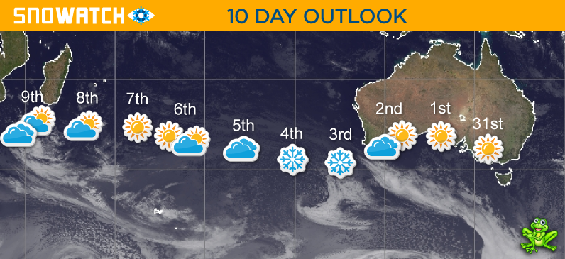
10 DAY OUTLOOK
Updated: August 1st, 6:36am (Forecast Period 6am-6am<)
SATURDAY 1ST

Morning
➤
Midday
➤
Night
SNOW: 0cm
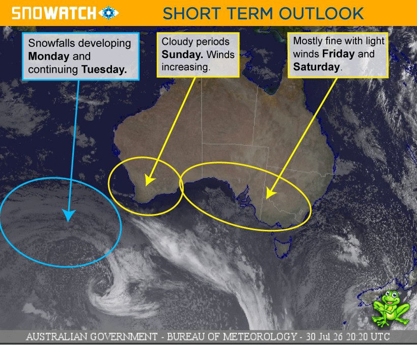
A mostly fine and sunny day. Winds increasing overnight.
CURR TEMP
-2.8
SNOWMAKING
POSSIBLE
WIND
N-NNW
LIGHT
➤
MODERATE

SUNDAY 2ND
Morning
➤
Midday
➤

Night
SNOW: 0cm
A mostly fine day in the south. Cloudy periods in the north. Winds strong about the peaks.
SNOWMAKING
POSSIBLE
WIND
N-NNW
STRONG
MONDAY 3RD

Morning
➤

Midday
➤
Night
SNOW: 3 - 7cm
Cool and windy with snowfalls developing, and reaching down to around 1200m.
SNOWMAKING
LIKELY
WIND
NW-WNW
STRONG

TUESDAY 4TH
Morning
➤
Midday
➤
Night
SNOW: 1 - 2cm
Cloudy with light scattered snow showers above 1300-1400m. Winds gusty about the peaks and easing overnight.
SNOWMAKING
POSSIBLE
WIND
WNW-WSW
STRONG
WEDNESDAY 5TH
Morning
➤
Midday
➤

Night
SNOW: 0cm
A mostly cloudy day. Winds easing.
SNOWMAKING
LIKELY
WIND
SW-W
MODERATE
➤
LIGHT
THURSDAY 6TH
Morning
➤
Midday
➤
Night
SNOW: 0cm
A partly cloudy day, clearing later.
SNOWMAKING
POSSIBLE
WIND
SSW-SSE
LIGHT
FRIDAY 7TH
Morning
➤
Midday
➤
Night
SNOW: 0cm
A mostly fine day with some cloudy periods in the afternoon.
SNOWMAKING
POSSIBLE
WIND
NNW
LIGHT
SATURDAY 8TH
Morning
➤
Midday
➤

Night
SNOW: 0 - 1cm
Cloud and winds increasing during the afternoon. Light showers developing overnight - falling as snow above around 1700-1800m.
SNOWMAKING
UNLIKELY
WIND
NNW
MODERATE
➤
STRONG
SUNDAY 9TH
Morning
➤
Midday
➤
Night
SNOW: 5 - 9cm
Light showers during the morning, with possible snow about the peaks. Snowfalls developing later and becoming heavy at times overnight above 1400-1500m.
SNOWMAKING
UNLIKELY
WIND
NNW-SSW
STRONG
MONDAY 10TH
Morning
➤
Midday
➤
Night
SNOW: 0 - 1cm
Cloudy with light scattered snow showers above 1500m during the morning. Clearing overnight.
SNOWMAKING
UNLIKELY
WIND
NNW-NW
STRONG
TUESDAY 11TH
Morning
➤
Midday
➤
Night
SNOW: 0cm
Mostly fine with the occasional cloudy period in the north.
SNOWMAKING
UNLIKELY
WIND
SW-S
LIGHT
WEDNESDAY 12TH
Morning
➤
Midday
➤
Night
SNOW: 0cm
Mostly fine with the occasional cloudy period in the north.
SNOWMAKING
POSSIBLE
WIND
SSW-S
LIGHT
THURSDAY 13TH
Morning
➤
Midday
➤
Night
SNOW: 0cm
Mostly fine early with cloud increasing during the day in the south.
SNOWMAKING
POSSIBLE
WIND
SW-S
LIGHT
➤
MODERATE
FRIDAY 14TH
Morning
➤
Midday
➤
Night
SNOW: 0cm
Cloud and winds increasing with possible showers developing later.
SNOWMAKING
UNLIKELY
WIND
NNW
MODERATE
➤
STRONG
SATURDAY 15TH
Morning
➤
Midday
➤

Night
SNOW: 5 - 15cm
Showers turning to snow during the day as a cool change arrives. Winds strong about the peaks.
SNOWMAKING
LIKELY
WIND
NNW-WNW
STRONG