After two of the worst snow seasons on record, how are we looking for Season 2025?

By Pete ‘The Frog’ Taylor
Snow Forecaster & Owner
snowatch.com.au
Snowatch® Early Season Outlook 2025
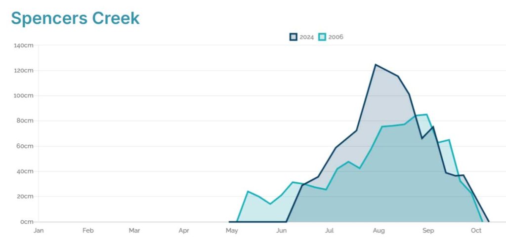
It is that time again when we look towards the new snow season after two of the worst seasons on record. Season 2024 will go down as once of the worse ones. Season 2023’s snow depth was only 7cm more, so it’s been two years of very ordinary snow. These depths are not the worst recorded, with 2006 only reaching 85cm, 1982-91cm and 1993 only got to 112cm. This shows that we have had bad seasons before and come back. For those that think it’s all over and we will never see deep snow again, remember that 2017, 2018, 2019 and 2022 all reached well over 2m in snow depth at Spencer’s Creek and 2021 was just below 2m.
How is early 2025 looking?
To come.
What usually happens this time of year?
Usually during May and June we see a lot of large dominating blocking high pressure systems revolving around the southern hemisphere bringing extended periods of dry weather with most potential snow bearing cold fronts being forced south under the mainland. Any snowfalls we see before June usually melts quite quickly, although it can help freeze the ground which helps the snow makers to create a base layer of snow.
So, when will it snow?
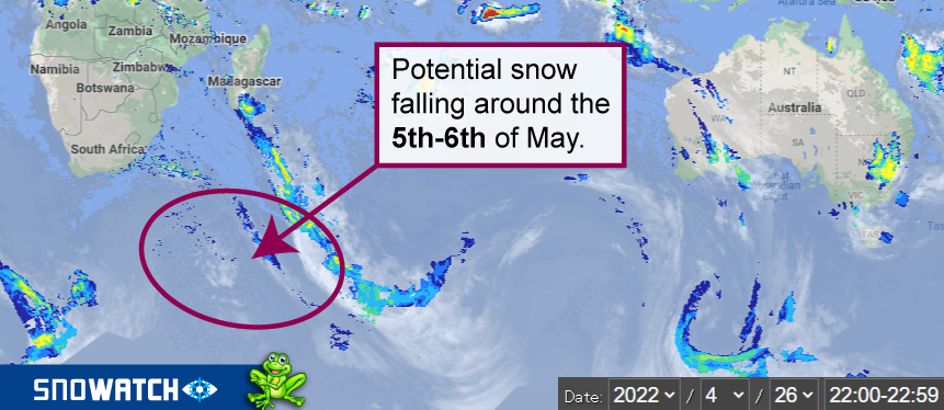
Looking at the current charts the next week looks quite mild and warm with temps dropping on the 4th. There is a chance of light snow falling around the 5th to 6th of May. It won’t last long on the ground but will more than likely increase the anxiety levels for the coming season.
Looking a bit further ahead I see temps milder than usual and quite a lot of moisture around which won’t be good for potential snow making leading into the season opening on June 11.
If I had to throw out some dates for potential for snow, I’d say around the 12th-13th of May and then a follow up system around the 21st-23rd of May.
In summary
In Summary I see a slow start to the season with limited snow making opportunities and unfortunately not a lot of natural snow. I think this pattern will remain until La Nina weakens more which probably won’t happen until July sometime. As this happens the likelihood of good consistent snowfalls will, and I think the back end of the season from mid-July to September will be quite decent.
All it takes for the season to get into full swing is a couple of decent falls so there is nothing to say an early dump can’t change things before July.
The daily Snowatch® forecasts begin on Monday 2nd May and as per usual you will see a 15 day forecast for each resort as well as a long range outlook for the next month pin pointing any future snowfalls to help in planning your next snow trips.
About Snowatch®
Snowatch.com.au is Australia’s longest running dedicated snow forecasting website. Owned and operated by Pete ‘The Frog’ Taylor it is well known for pinpointing snow bearing systems up to four weeks out. Unlike other weather sites Snowatch® does not rely on automated algorithms to pump out snowfall predictions. Pete ‘The Frog’ is up early 7 days a week from May 1st through to closing weekend in October studying the charts and data before manually inputting forecasts for each resort for the next 15 days as well as adding his thoughts on the long rang outlook. Pete ‘The Frog’ also helps out fellow Snowatcher’s answering emails and facebook messages in regards to queries on coming snowfalls. There is also a 7 day forecast for the New Zealand snowfields around Queenstown and Wanaka for the Aussies who like to keep an eye out over the ditch.

I live in the Ruapehu District. I ski turoa and whakapapa. Plus I go south and ski craigieburn and lots of other ski fields in the south island. If I could get some weather reports it would be great brilliant. Tight lines. No ice at Ruapehu.
Let’s hope your wrong
I hope it’s wrong and we get some early dumps also. It’s still possible, we just need some cold air to mix in with the moisture at the right time.
We managed two weeks early August last year before Covid closed everything down. If the snow this August is anything like kast year it’ll be awesome!
Looking forward to your forecasts again Pete!
Frog, any chance the Tongan Volcano eruption will bring massive dumps? I suspect a lot of the East Coasts bizarre weather (flooding rain in May as I write) is related to volcanic ash in the atmosphere. The same ash if it indeed exists could bring seriously big snow this season. Have previous huge years coincided with Southern Hemisphere volcanic activity? Last year was good as you say, and Whites Island NZ erupted in December 2021 which also would have put ash into the atmosphere.
I would say from long experience it’s going to be a late (to possibly very late) season. It is very wet, with really boggy surface groundwater everywhere and it is very humid so that’s not a great sign for ground temps. Too cold to grow vegies but too hot to hold snow…Oh the joys of alpine life!