
Season 2026 end of season wrap
By Pete ‘The Frog’ Taylor
Snow Forecaster & Owner
snowatch.com.au
There were high hopes for Season 2026, but with the thought of an El Niño raising its head later in the season, there was also some pessimism around. The lead-up to Season 2026 was certainly not a normal one.
We saw a run of warm nights, or nights where the humidity was simply too high for the snow guns to fire. Usually, from mid-May, the resorts fire up the guns whenever conditions are right and start building a base, allowing some early skiing and snowboarding.
Mt Buller has had Snow Factory technology for many years now, producing ice from a hose coming out of the shipping container that houses the factory. The technology can produce snow in temperatures of up to 20°C. Large piles of snow, known as “whales”, are built up and then spread across the slopes before opening weekend.
Thredbo has also invested in this technology and has been pumping out snow on Friday Flat, the lowest part of any Australian resort at 1,365m, since May.
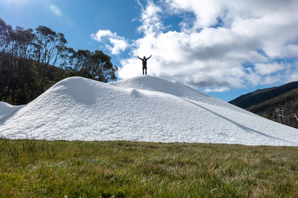
In a season that has seen minimal low-level natural snowfall, this technology has been a game changer. Mt Buller has been able to keep Bourke Street open, while Thredbo has kept Friday Flat operating from June through September.
The opening weekend did have a little snow on the ground, thanks to a decent fall just before opening. We also had a couple of cold nights when the snow guns were able to fire up, and Front Valley at Perisher opened on the Sunday.
Unfortunately, the warm nights soon returned and we saw very little snowmaking through June. By the end of the month, we were staring at what looked like the worst start to a season on record, with virtually no natural snow on the ground.
July saw temperatures drop and the snow guns finally fired up properly. We also saw some light natural snowfalls, allowing a base to develop and a number of runs to start opening over the following weeks. It looked like we were finally getting back on track.
The high-pressure systems that had been sitting further south than normal through June, pushing potential cold fronts underneath the mainland, had shifted. Optimism was high.
Satellite images were showing cold fronts lining up to arrive through August. In particular, the first weekend of August promised a big dump overnight on the Sunday, with more snow to follow. It looked like the snowfall that would finally set up the season and allow much more terrain to open.
All forecasters, including myself, and the weather bureaus were predicting big falls. But Mother Nature had other ideas and threw warm air into the mix for much longer than we had anticipated.
The result was a big dump of rain, with Thredbo receiving around 80mm, washing away a large chunk of the snow that had fallen during July.
We did see snow falling after the rain, with Hotham, Falls Creek and Perisher receiving around 25–40cm during this period. A few more runs were able to open, so there was still a glimmer of hope.
Some snowmaking also took place, which helped preserve the cover, but temperatures remained too warm and the snow had started to melt. The cold fronts that did make it into the mountains often delivered more wet stuff than frozen stuff.
Strong winds were also thrown into the mix for a couple of weeks, much like August and September 2023 and 2024. The resulting “hairdryer” effect accelerated the snow melt considerably.
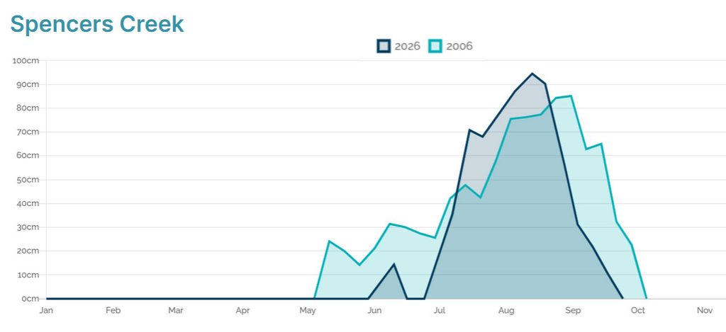
The official Spencer’s Creek snow depth reading, taken by Snowy Hydro and used to compare seasons, reached a peak of just 94.5cm on August 13.
This wasn’t quite the lowest peak on record — 1982 reached 91cm on August 19, while 2006 reached 85.1cm on August 31 — but 2026 was the earliest season on record to peak below one metre.
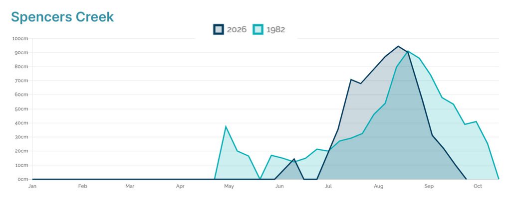
The main difference between these seasons is significant. In 1982, although there was no snowmaking, there was a much better base at lower elevations. In 2006, there was already a 30cm base on June 8, and it remained above 30cm until late September.
We saw Selwyn close first on August 20. Unfortunately they hardly saw anywhere open away from the beginners New Chum Chair. The Racecourse wasn’t able to open at all during the season. It was yet another tough one for Selwyn. Baw Baw was next to close on the 23rd of August.
Heavy rain on September 5th saw most resorts on their last legs. Perisher receiving 115mm, Falls Creek 109mm, Hotham 96mm and Thredbo 77mm.
This rain washed away a lot of snow and saw Hotham and Falls Creek close on September 6 (a month early).
Thredbo were able to keep Friday Flat open until the 13th of September (without the snow factory it would have been a month earlier). The amazing team at Perisher were somehow able to keep most of Front Valley, and even parts of Centre Valley and up to Mid Station open til late September, with the last lift (the V8) closing on the 25th, (just a couple weeks shy of the proposed official closing date).
The resort mountain operations staff, groomers and snowmakers have done a sensational job under incredibly difficult circumstances to keep this season going for as long as they have, with so little natural snowfall.
I applaud their efforts. They are greatly appreciated by everyone who has been able to enjoy the mountains this season.
I also really feel for all the businesses that rely on snow to survive — accommodation providers, food and restaurant outlets, ski and snowboard hire shops, retailers, travel companies and many others.
If you are heading overseas to ski or snowboard during the off-season, please try to support our local suppliers and buy your gear from them where possible. Every bit helps.
Thank you to everyone who visited Snowatch this season.
It has been an extremely difficult season to forecast, with marginal temperatures and snow levels making things particularly challenging. I’ve received more messages this year asking about upcoming weather, advice on booking dates, and whether people should change or cancel trips than at any other time.
I know that, more often than not, the answers weren’t what people wanted to hear. But when people are spending their hard-earned money on a ski trip, I feel it’s important to be honest about the conditions and the risks.
The main thing that sets Snowatch apart from other snow websites offering forecasts. Snowatch is done manually. The forecasts aren’t simply spat out automatically by algorithms. Every morning from May 1 until the end of the season, I study charts, weather models, satellite images and data. I write every forecast myself and change the morning, daytime and nighttime weather icons for each resort for the following 15 days, every single day. I also publish my outlook further ahead. Obviously, long-range forecasts can’t be correct all the time, but even when the timing isn’t perfect, the arrival of weather systems can often be picked up surprisingly well — and that can be extremely useful when planning a ski trip.
This year I’ve also tried to be much more visible and engaging, with daily social media posts. It looks like that has helped spread the word, with website visitor numbers up around 40% on last year, while Facebook and Instagram numbers have also increased significantly.
A huge thank you to the Liquid Radio Network for hosting my snow reports every day since early June. It’s sad that we are finishing a month earlier than planned, but now I’m looking forward to next season, which surely has to be an improvement!
Although the Australian season is now coming to an end, I’ll still be keeping a close eye on what’s happening overseas as winter arrives in the Northern Hemisphere and the snow begins to fall over the coming months. Snowatch will still be active and posting up news as it happens.
For those still needing a snow fix — and with the funds to make it happen — there is still plenty of snow over the ditch for the next month. To everyone heading north for the off-season, I hope you have a much better season than we did!
Until next season (Forecasts begin May 1). Stay safe, and thanks again for your support of Snowatch throughout Season 2026.
Pete ‘ The Frog’ Taylor
