Village Elevation: 1760m / Summit Elevation: 1964m / Total number of lifts: 5 / Highest Lifted Point: 1964m / Lowest Lifted Point: 1755m
 Forecasts by
Pete ‘The Frog’ Taylor

LIVE TEMP:
PREDICTED SNOWFALL
NEXT 5 DAYS: 0cm
NEXT 10 DAYS: 0cm
NEXT 15 DAYS: 5-10cm
LIVE CAMS

NEXT 4 DAYS
10 DAY OUTLOOK
Updated: June 16th, 6:44am (Forecast Period 6am-6am<)
MONDAY 16TH

Morning
➤
Midday
➤

Night
SNOW: 0cm
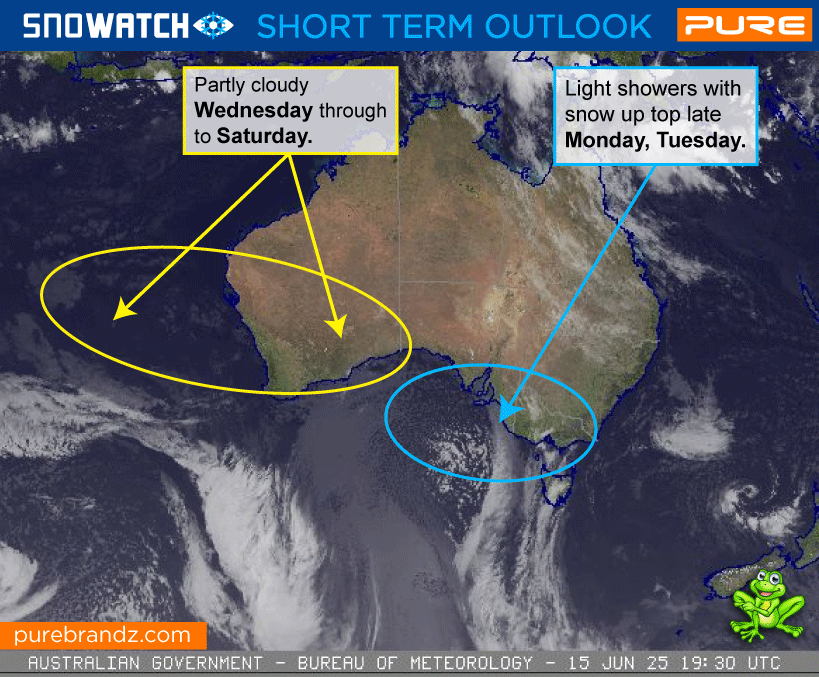
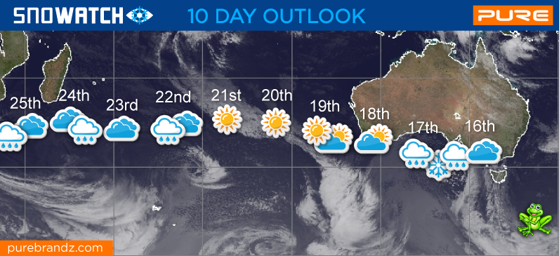
Cloudy with light showers developing in the south during the day and extending north overnight. Possible snow about the peaks later.
CURR TEMP
SNOWMAKING
UNLIKELY
WIND
NNW-WNW
STRONG

TUESDAY 17TH
Morning
➤
Midday
➤

Night
SNOW: 0cm
Cool and cloudy with the chance of some light snow flurries above 1600-1700m.
SNOWMAKING
POSSIBLE
WIND
W-WSW
STRONG
➤
MODERATE
WEDNESDAY 18TH

Morning
➤
Midday
➤
Night
SNOW: 0cm
A partly cloudy day.
SNOWMAKING
LIKELY
WIND
W-NW
LIGHT


THURSDAY 19TH
Morning
➤
Midday
➤
Night
SNOW: 0cm
A partly cloudy day.
SNOWMAKING
LIKELY
WIND
NW
LIGHT
FRIDAY 20TH
Morning
➤
Midday
➤
Night
SNOW: 0cm
A mostly fine day with the occasional cloudy period.
SNOWMAKING
LIKELY
WIND
NNE
LIGHT
SATURDAY 21ST
Morning
➤
Midday
➤
Night
SNOW: 0cm
A mostly fine and sunny day.
SNOWMAKING
POSSIBLE
WIND
NNW
LIGHT
SUNDAY 22ND
Morning
➤
Midday
➤
Night
SNOW: 0cm
CLoud increasing during the day with showers developing overnight.
SNOWMAKING
UNLIKELY
WIND
NNW-NW
STRONG
MONDAY 23RD
Morning
➤
Midday
➤
Night
SNOW: 0cm
Cloudy and windy with light scattered showers during the morning that will clear later.
SNOWMAKING
POSSIBLE
WIND
WNW-NW
STRONG
TUESDAY 24TH
Morning
➤
Midday
➤
Night
SNOW: 0cm
Cloudy with light scattered showers at times.
SNOWMAKING
UNLIKELY
WIND
NW-NNW
MODERATE
WEDNESDAY 25TH
Morning
➤
Midday
➤
Night
SNOW: 0cm
Cloudy with light showers. that will ease overnight in the south.
SNOWMAKING
UNLIKELY
WIND
NNW
MODERATE
THURSDAY 26TH
Morning
➤
Midday
➤

Night
SNOW: 0cm
Cloudy with light scattered showers falling as snow at times above around 1600-1700m.
SNOWMAKING
UNLIKELY
WIND
NNW-WNW
MODERATE
FRIDAY 27TH
Morning
➤
Midday
➤
Night
SNOW: 0cm
Cloudy with light scattered showers at times with snow flurries above 1600-1700m.
SNOWMAKING
POSSIBLE
WIND
S-SSE
MODERATE
SATURDAY 28TH
Morning
➤
Midday
➤
Night
SNOW: 0cm
Cool and cloudy with possible light snow flurries at times.
SNOWMAKING
UNLIKELY
WIND
SSE-SE
MODERATE
SUNDAY 29TH
Morning
➤
Midday
➤
Night
SNOW: 0cm
Cloudy with light scattered showers falling as snow later above 1500-1600m.
SNOWMAKING
UNLIKELY
WIND
SSE-SE
MODERATE
MONDAY 30TH
Morning
➤
Midday
➤
Night
SNOW: 5 - 10cm
Cloudy with snow showers developing as a cool change arrives.
SNOWMAKING
POSSIBLE
WIND
WNW-SW
MODERATE
➤
STRONG