
| NEW SOUTH WALES | |||
| Snow forecast | 5 Days | 10 Days | 15 Days |
| Perisher | 7-17cm | 22-45cm | 45-83cm |
| Thredbo | 7-17cm | 22-45cm | 45-83cm |
| Charlotte Pass | 7-15cm | 14-33cm | 37-71cm |
| Selwyn | 8-13cm | 22-38cm | 40-77cm |
| VICTORIA | |||
| Snow forecast | 5 Days | 10 Days | 15 Days |
| Falls Creek | 20-30cm | 40-71cm | 69-123cm |
| Mt Hotham | 20-30cm | 40-71cm | 69-123cm |
| Mt Buller | 10-25cm | 28-66cm | 59-122cm |
| Mt Baw Baw | 2-6cm | 7-20cm | 8-24cm |
Please note: the 10-15 day readings are more likely to change due to the longer range timeframe.
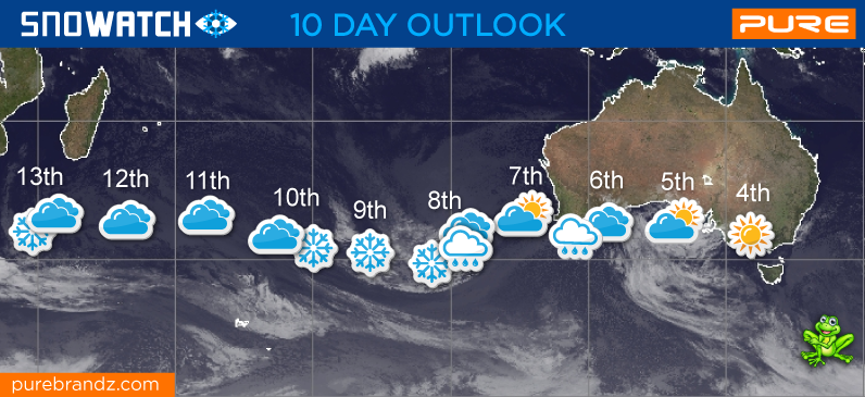
The next couple of days will be a good time to hit the slopes. Mostly sunny with moderate winds.
Looking ahead it's pretty good news with consistent cold fronts dropping more snow over the next couple of weeks. A cold front arriving on the 8th looks like dropping some decent amounts of snow across the 8th-10th. Following this a weak front on the 13th could drop a little snow..
Further ahead more snow across the 15th-17th and this once again looks to be a decent amount of snow from a nice cold blast. Once this one passes all resorts should have a deep cover of snow, not often seen at this time of the season.
Long range the 21st-23rd also looks like we could see another snow bearing front arriving to continue adding to the cover.
Pete 'The Frog' Taylor
....
If publishing any of the above forecast outlook please quote Snowatch.com.au as the source.

| JULY | ||||||
| SUN | MON | TUE | WED | THU | FRI | SAT |
| 1 | 2 | 3 | 4 | 5 | ||
| 6 | 7 | 8 | 9 | 10 | 11 | 12 |
| 13 | 14 | 15 | 16 | 17 | 18 | 19 |
| 20 | 21 | 22 | 23 | 24 | 25 | 26 |
| 27 | 28 | 29 | 30 | 31 | ||
| AUGUST | ||||||
| SUN | MON | TUE | WED | THU | FRI | SAT |
| 1 | 2 | |||||
| 3 | 4 | 5 | 6 | 7 | 8 | 9 |
| 10 | 11 | 12 | 13 | 14 | 15 | 16 |
| 17 | 18 | 19 | 20 | 21 | 22 | 23 |
| 24 | 25 | 26 | 27 | 28 | 29 | 30 |
| 31 | ||||||
| No Snow | Light Snow | Heavy Snow |